Bhubaneswar: A low pressure is likely to form over southeast Bay of Bengal and adjoining south Andaman Sea by December 5, and concentrate into a depression over southeast Bay of Bengal by December 7 morning, the India Meteorological Department (IMD) said.
“Thereafter, it is likely to continue to move west-northwestwards and reach southwest Bay of Bengal near north Tamil Nadu-Puducherry and adjoining south Andhra Pradesh coasts by December 8 morning,” it said.
The system is likely to trigger rainfall activity in north coastal Tamil Nadu, Puducherry and Karaikal and South coast Andhra Pradesh at midnight of December 7. Squally wind speed reaching 40-50 kmph gusting to 60 kmph is also likely to commence along & off Tamil Nadu, Puducherry and South Andhra Pradesh coast from December 8 morning, the MeT office predicted.
Dry weather will continue to prevail in the rest of the country for the next two days. Several parts of northwest India may see a warmer winter primarily due to likely subdued activity of western disturbances, it added.
Odisha will also continue to witness dry weather conditions till December 6.
Last night, Kirei in Sundargarh was the coldest at 11 degree Celsius followed by Koraput at 11.5 degree Celsius. The other places where the mercury dropped below 15 degree Celsius are Keonjhar (13.8), Sundargarh (14), G Udayagiri and Daringbadi in Kandhamal at 14.2 degree Celsius and 14,5 degree Celsius respectively and Jharsuguda (14.5).
The twin cities of Bhubaneswar and Cuttack recorded 16.8 degree Celsius and 18.1 degree Celsius respectively.
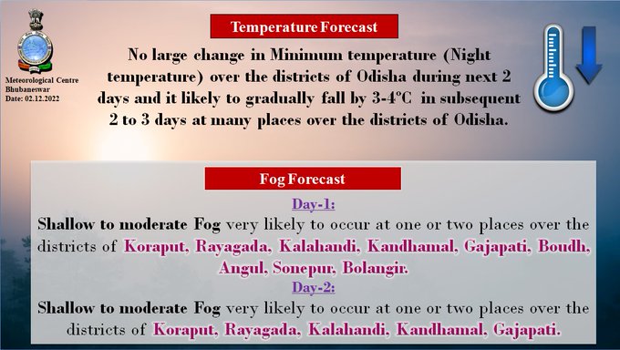
While the night temperature has remained appreciably above normal (3.1°C to 5.0°C) at most places in the state, the IMD has forecast a dip in the mercury by 3-4°C from Tuesday.
Comments are closed.